Top Civil Engineering Tech: Expert Insights & Advanced Solutions
Civil engineering stands at the intersection of innovation and infrastructure, where cutting-edge technology transforms how we design, build, and maintain the world around us. From drone surveying systems to AI-powered project management platforms, the civil engineering sector has undergone a dramatic technological revolution in recent years. Engineers today leverage sophisticated software, real-time monitoring systems, and computational tools that would have seemed like science fiction just a decade ago. This comprehensive guide explores the most impactful civil engineering technologies currently reshaping the industry, providing expert insights into tools that are becoming essential for modern infrastructure projects.
The integration of advanced technology into civil engineering workflows has fundamentally changed project timelines, accuracy levels, and cost efficiency. Whether you’re managing a highway expansion, designing a bridge, or overseeing urban development, understanding these technological advances is crucial for staying competitive. This article examines the leading solutions, their practical applications, and why they matter for the future of infrastructure development.
Building Information Modeling (BIM) Revolution
Building Information Modeling has emerged as perhaps the most transformative technology in civil engineering over the past decade. BIM represents a fundamental shift from traditional 2D drafting to comprehensive 3D digital representations of entire projects. Unlike conventional CAD drawings, BIM creates intelligent models where every component carries metadata, relationships, and real-world properties. This enables unprecedented coordination between architects, engineers, contractors, and stakeholders throughout the project lifecycle.
The sophistication of modern BIM platforms allows teams to simulate construction sequences, detect clashes before they occur on-site, and generate accurate material takeoffs automatically. Leading platforms like Autodesk Revit have become industry standards, with competitors like Trimble SketchUp and Bentley Systems offering specialized solutions for different project types. The collaborative nature of BIM means that design changes propagate instantly across all team members’ views, eliminating the communication breakdowns that previously plagued large infrastructure projects.
Integration with cloud computing benefits for businesses has amplified BIM’s effectiveness, allowing geographically dispersed teams to work simultaneously on the same model. Real-time clash detection, which identifies when building components would physically interfere with each other, has saved projects millions in rework costs. The technology supports everything from small bridge designs to massive urban developments, with the ability to manage projects containing millions of individual components without performance degradation.
Cost savings from BIM implementation typically range from 5-10% of project budgets through reduced errors, improved coordination, and streamlined procurement. Many government agencies and major developers now mandate BIM compliance on projects exceeding certain thresholds, making proficiency in these tools essential for civil engineering professionals.

Drone Technology and Aerial Surveying
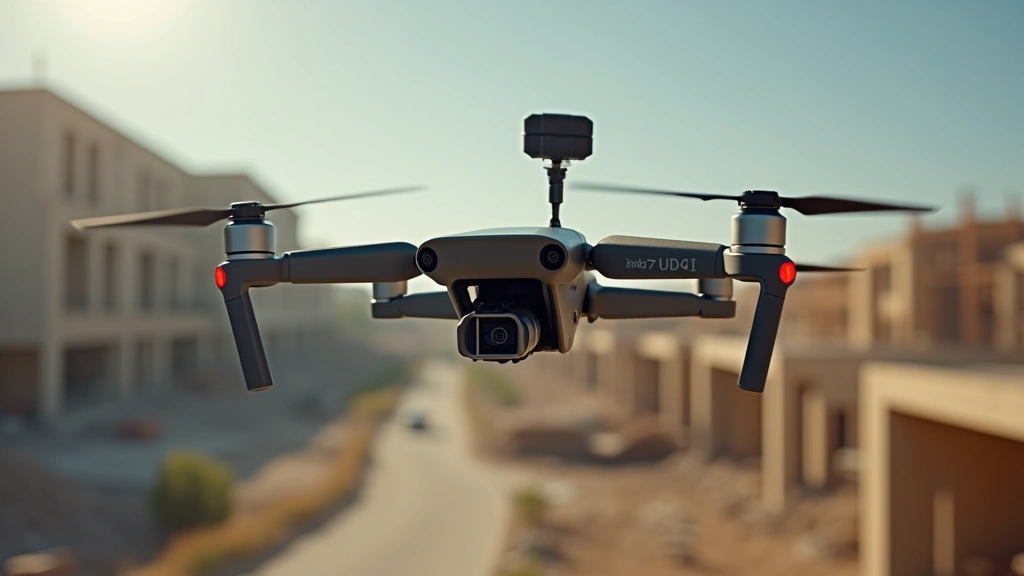
Unmanned aerial vehicles have revolutionized how civil engineers conduct site surveys and monitor ongoing construction. Traditional surveying methods required teams to physically access terrain, often in dangerous or difficult locations, with data collection taking weeks or months. Modern commercial drones equipped with LiDAR sensors and high-resolution cameras can survey hundreds of acres in a single flight, generating precise topographic data in days rather than weeks.
The accuracy achievable with current drone technology is remarkable—modern systems deliver positional accuracy within 2-3 centimeters when equipped with Real-Time Kinematic (RTK) GPS systems. This precision rivals or exceeds traditional surveying methods while dramatically reducing costs and project timelines. DJI’s enterprise platforms dominate the commercial market, though Freefly and Trimble offer specialized solutions for specific applications. The data collected by drones generates point clouds and orthomosaics that feed directly into design software, creating seamless workflows from field to office.
Beyond initial surveying, drones provide continuous monitoring capabilities throughout construction phases. Progress documentation, volume calculations for stockpiles, and quality verification become faster and more objective when using aerial imagery. For linear infrastructure projects like highways and pipelines, drone surveys reduce ground-based fieldwork by 60-80%, significantly improving worker safety in hazardous environments. The thermal imaging capabilities of modern drones also enable detection of structural issues, water infiltration, and subsurface features invisible to conventional methods.
Integration with project management platforms allows drone data to flow directly into progress tracking systems, creating automated reporting that updates stakeholders in real-time. The combination of drone surveying with artificial intelligence applications transforming the future enables automated feature detection and change analysis that would require hours of manual interpretation.
AI and Machine Learning Applications
Artificial intelligence is increasingly driving decision-making in civil engineering projects, from predictive maintenance of existing infrastructure to optimized design generation. Machine learning algorithms analyze historical project data to predict cost overruns, schedule delays, and resource constraints with accuracy levels exceeding human estimation. These predictive models become increasingly accurate as organizations accumulate more project data, creating a virtuous cycle of continuous improvement.
In the realm of structural analysis, AI-powered tools now generate optimized designs that meet performance requirements while minimizing material usage. Parametric design systems leverage machine learning to explore thousands of design variations in hours, identifying solutions that balance aesthetics, functionality, and cost in ways traditional engineering workflows cannot match. DesignSpark and similar platforms demonstrate how AI augments rather than replaces human engineers, handling computational optimization while engineers focus on creative problem-solving and validation.
Computer vision applications powered by deep learning enable automated quality inspection on construction sites. Cameras mounted on drones or vehicles analyze concrete surfaces, detecting cracks, delamination, and other defects with consistency that exceeds manual inspection. This technology catches problems early when corrections are less expensive, improving overall project quality and reducing warranty claims.
Predictive maintenance systems for existing infrastructure use AI to analyze sensor data from bridges, tunnels, and other structures, identifying degradation patterns before catastrophic failure occurs. These systems have proven particularly valuable for aging infrastructure, where condition monitoring enables targeted maintenance that extends asset life while optimizing maintenance budgets. The economic impact of preventing infrastructure failures through predictive maintenance runs into billions annually across developed nations.
Cloud Computing for Project Management
The shift to cloud-based project management represents a fundamental change in how civil engineering teams collaborate and share information. Traditional on-premise systems required expensive infrastructure and limited accessibility, while modern cloud platforms provide real-time access to project data from any location. Platforms like ProjectMates and Touchplan enable teams spanning multiple offices and time zones to maintain synchronized workflows.
Cloud infrastructure supporting civic tech initiatives enables cities and municipalities to manage complex infrastructure portfolios more effectively. Asset management systems track thousands of infrastructure components—pipes, roads, bridges, utilities—providing comprehensive visibility into maintenance needs and performance metrics. This centralized approach to infrastructure management has transformed how cities approach preventive maintenance and capital planning.
Document management capabilities in cloud platforms eliminate the chaos of version control that plagued traditional project workflows. Every modification to specifications, drawings, or reports is timestamped and traceable, creating complete audit trails that satisfy regulatory requirements and facilitate dispute resolution. The ability to instantly distribute updated information to all stakeholders reduces costly errors from outdated information.
Integration capabilities allow cloud platforms to connect with specialized engineering tools, creating unified workflows where data flows seamlessly between analysis software, project management systems, and accounting platforms. This integration eliminates manual data re-entry, reduces errors, and accelerates information flow throughout organizations.

IoT Sensors and Real-Time Monitoring
Internet of Things sensor networks have transformed infrastructure from static assets into intelligent systems that continuously report their condition. Structural health monitoring systems deployed on bridges, dams, tunnels, and high-rise buildings use accelerometers, strain gauges, and displacement sensors to track behavior in real-time. These systems detect subtle changes in structural response that indicate emerging problems, enabling preventive intervention before safety becomes compromised.
Smart concrete sensors embedded during construction provide continuous monitoring of curing processes and long-term performance. These sensors measure temperature, humidity, and stress levels, ensuring optimal curing conditions and documenting the structural integrity history from the moment concrete is placed. This data proves invaluable for forensic analysis if problems develop, as it provides an objective record of conditions throughout the structure’s life.
Environmental monitoring networks track air quality, noise levels, vibration, and other parameters around construction sites and operating infrastructure. These systems provide objective data for regulatory compliance and community relations, replacing subjective observations with quantifiable measurements. Real-time alerts notify operators when parameters exceed acceptable ranges, enabling rapid response to potential issues.
The convergence of IoT monitoring with tech pulse hunter blog insights reveals emerging patterns in how infrastructure performs under various conditions. Machine learning algorithms analyze this sensor data to identify correlations between environmental factors and structural performance, enabling predictive models that anticipate problems before they manifest as failures.
Advanced Simulation and Modeling Software
Modern finite element analysis (FEA) software enables engineers to simulate structural behavior with remarkable accuracy before construction begins. Platforms like ANSYS and COMSOL allow engineers to test designs against earthquakes, extreme winds, floods, and other scenarios that would be impossible to physically test. These simulations reveal stress concentrations, instability modes, and failure mechanisms that might otherwise only become apparent during catastrophic failure.
Computational fluid dynamics (CFD) applications simulate water flow through drainage systems, around bridge piers, and through ventilation networks. This capability enables optimization of designs for hydraulic efficiency, sediment transport, and environmental impact. The ability to virtually test hundreds of design variations accelerates convergence to optimal solutions that balance multiple competing objectives.
Geotechnical analysis software simulates soil behavior under various loading and environmental conditions. These tools model slope stability, foundation settlement, liquefaction potential, and other soil-structure interactions that critically affect project success. The integration of site investigation data with sophisticated soil models enables realistic predictions of subsurface behavior throughout project lifecycles.
Traffic simulation software models complex transportation networks, predicting congestion patterns, safety implications, and environmental impacts of proposed infrastructure changes. These tools enable data-driven decision-making about roadway design, signal timing, and transit integration that improves both functionality and livability of transportation systems.
Augmented Reality in Field Operations
Augmented reality technology brings design intent directly to construction sites, overlaying digital models onto physical environments. Workers wearing AR devices or using mobile devices can view exactly where utilities run beneath the surface before excavation begins, eliminating costly and dangerous utility strikes. Design elements appear at their actual locations, enabling workers to verify that construction matches design specifications in real-time.
AR-assisted installation of complex systems like mechanical, electrical, and plumbing networks dramatically reduces installation errors and rework. Workers see step-by-step guidance overlaid on the physical space, with assembly sequences and component locations highlighted precisely. This technology proves particularly valuable for training new workers, as experienced technicians can demonstrate procedures while novices see exactly what to do overlaid on their environment.
Quality inspection workflows using AR enable inspectors to compare as-built conditions against design specifications in real-time. Discrepancies appear highlighted, with automated documentation capturing photos and measurements that feed into project records. This real-time feedback enables immediate correction of problems rather than discovering them during final inspections.
Specifications and Performance Metrics
Understanding the specifications of civil engineering technology platforms enables informed selection for specific project requirements. BIM software typically requires 4-8GB of RAM for standard projects, though large infrastructure models may demand 16GB or more. Processing power scales with model complexity, with quad-core processors providing adequate performance for most applications while high-end workstations with 8+ cores accelerate analysis on massive models.
Drone systems for surveying range from consumer models costing under $1,000 to enterprise platforms exceeding $50,000. RTK-equipped systems achieving centimeter-level accuracy typically cost $15,000-$35,000, with ongoing subscription costs for positioning services ranging $100-$500 monthly. Flight times vary from 20-45 minutes depending on payload and battery capacity, with professional systems requiring 1-2 hours between charges.
Cloud platform subscriptions typically range from $50-$500 monthly per user depending on functionality and storage requirements. Enterprise deployments often negotiate volume discounts, reducing per-user costs for large organizations. Data storage costs vary from $0.02-$0.10 per gigabyte monthly, with typical projects requiring 500GB-5TB of cloud storage.
IoT sensor systems cost $500-$5,000 per installation point, with wireless communication infrastructure adding $10,000-$50,000 depending on site size and transmission range. Long-term maintenance and data processing typically runs $100-$500 per sensor annually.
FAQ
What is BIM and why do civil engineers need it?
Building Information Modeling creates intelligent 3D digital representations of projects containing detailed information about every component. Civil engineers need BIM because it enables coordination between disciplines, detects design conflicts before construction, generates accurate material quantities, and facilitates collaboration across geographically dispersed teams. BIM reduces errors by 80% compared to traditional 2D drafting methods.
How accurate are drone surveys for civil engineering projects?
Modern RTK-equipped drones achieve positional accuracy within 2-3 centimeters, which meets or exceeds traditional surveying methods. Accuracy depends on GPS signal quality, atmospheric conditions, and equipment calibration. For most civil engineering applications, this accuracy level proves sufficient for design and construction purposes.
Can AI really predict project delays and cost overruns?
Machine learning models analyzing historical project data can predict delays and cost overruns with 70-85% accuracy when trained on sufficient data. Accuracy improves over time as organizations accumulate more project information. These predictions enable proactive management interventions that prevent problems from escalating.
What’s the learning curve for BIM software?
Basic BIM proficiency typically requires 40-80 hours of training and practice. Full expertise enabling efficient complex project modeling requires 6-12 months of regular use. Many universities now include BIM training in civil engineering curricula, making it standard knowledge for recent graduates.
How does IoT monitoring improve infrastructure maintenance?
IoT sensors provide continuous real-time data about infrastructure condition, enabling detection of problems before failure occurs. Predictive maintenance based on sensor data reduces emergency repairs by 40-60% and extends infrastructure life by 10-15%, generating substantial cost savings over time.